
Panama City / Research guide
Use official geographic information for property research in Panama
Check the purpose, scale and date of IGN Tommy Guardia cartography alongside a building record without treating either as a price.
Begin with the purpose, scale and date of the geographic product, rather than assuming every official map answers the same property question. Territorial cartography, a building outline and an identified parcel represent different objects. None establishes a market price on its own.
Start with the publishing institution
The Instituto Geográfico Nacional Tommy Guardia within ANATI provides information about digital cartography. Its Photogrammetry and Remote Sensing department describes work with imagery and mapping products. Consult the institution for the relevant product and its current access conditions.
Digital cartography does not imply an open service containing every parcel in Panama. This guide does not claim that Terraes has a nationwide ANATI parcel integration. If an institutional page cannot be reached, record the access problem and return through the institution's website rather than interpreting the failure as missing property information.
Read the layer before comparing shapes
Identify what the visible layer represents. Check its units, geographic coverage, date and scale information. Zooming further into an image on a screen does not improve the precision of the underlying source.
When comparing a building location, inspect junctions, block shape and the relative position of neighbouring features. If outlines disagree, do not shift or reinterpret them merely to force a match. First test whether they describe the same object, whether their dates differ and whether each source is appropriate for the question.
Keep any unresolved mismatch in your notes. An unexplained difference is a reason to investigate further, not permission to select whichever outline best fits the advertised area.
A concrete record from El Cangrejo
The P.H. Macabi building record, checked on September 22, 2026, came from Overture release 2026-08-19.0 with OpenStreetMap attribution retained. It showed a footprint of 534.21 m², while a matched parcel and unit area were unavailable.
This record is not presented as an ANATI product. It describes an observed structure in an open mapping source, including the fields that are missing. It does not establish a property boundary, identify an owner or measure an apartment inside the building.
Record the question you actually resolved
Save the source link, access date, layer and field used. Distinguish finding a building from verifying a parcel and from obtaining an asking-price reference. Resolving the first question is useful even when the others remain open.
When sharing a screenshot, retain relevant attribution and context and include the source link. A cropped image can hide the legend or date needed to interpret it.
Continue with area definitions, neighbourhood research and the Panama hub. The methodology supplies shared evidence concepts without extending its Colombian model to Panama.
Watch the walkthrough
Silent video with captions. Press play to load the recording.
Watch page and full transcript →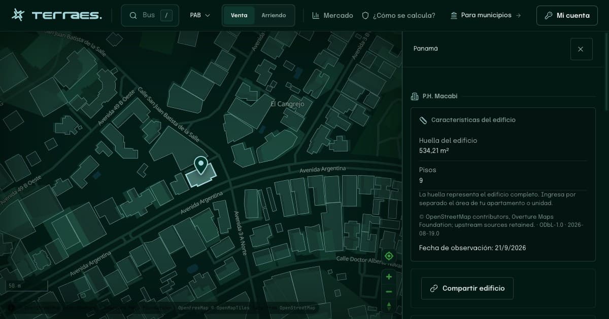
Continue your research
Research El Cangrejo and other Panama City neighbourhoods
Inspect blocks, entrances and everyday routes while keeping map observations separate from claims about a home or neighbourhood.
Read guide →02 · PanamaBuilding footprint, land and apartment area in Panama
Understand why an El Cangrejo building outline cannot establish the size of an apartment inside it.
Read guide →Sources and review
By Terraes editorial team · Published · Updated
- Instituto Geográfico Nacional Tommy Guardia — Cartografía digital · accessed 2026-09-22
- Overture Maps Foundation — Buildings · accessed 2026-09-22
Mapped footprints do not establish legal ownership or apartment floor area. Advertisements describe asking prices; area references are neither recorded sale prices nor official appraisals.