
Guatemala City / Research guide
Where to check official geographic information in Guatemala
Choose the right source for building exploration or cadastral information, and preserve its geography, date and limitations.
Choose a source according to the question you need answered. Locating a building in Guatemala and obtaining cadastral information about land are separate tasks. An exploratory building record can help you orient a search without becoming an institutional cadastral document.
Match the source to the question
Terraes supports building exploration and displays the provenance of its records. For institutional cadastral products, use the Registro de Información Catastral services portal. The portal provides a route to request the institution's products; check the current description and availability of the relevant service there.
That does not establish an open parcel feed for all of Guatemala, and this guide does not claim that Terraes has one. An address may require further identification before the appropriate product can be determined. If a website is temporarily inaccessible, record that as an access problem rather than evidence that the property does not exist.
Compare identity before comparing measurements
Keep the address, municipality, spatial reference and identifiers actually supplied by each source. A building identifier and a cadastral identifier are different identifiers unless a supported relationship links them. A similar name is not enough to create that relationship.
Next, check the object described by each field: a building, a plot or an individual unit. Only then compare measurements and dates. Record both the date you accessed the information and the source's own publication or observation date. A newly published dataset can contain fields observed much earlier.
If a map and a document disagree, begin with those identity and definition checks. Treating the larger figure as more authoritative, or choosing the newer-looking interface, does not resolve the underlying question.
A record with explicit limits
The Holiday Inn record in zona 10 was checked on September 22, 2026. It cited Overture release 2026-08-19.0 and retained OpenStreetMap attribution. Its footprint was 1,831.58 m²; a matched parcel and unit area were unavailable.
Those facts support a description of the observed cartographic record. They do not identify the owner, provide a cadastral number or measure a home inside the building. Unavailable fields remain open questions and should not be interpreted as adverse findings about the property.
Leave a trail someone else can follow
Save the source link, access date, field used and relevant limitation. Accompany a screenshot with the underlying link, since screenshots can omit legends, dates and the selection scope. When a later source changes your understanding, retain the reason for the correction rather than silently replacing the earlier value.
Continue with land and unit areas, address matching and the Guatemala hub. The methodology page provides shared estimation concepts without extending its Colombian model to these geographic records.
Watch the walkthrough
Silent video with captions. Press play to load the recording.
Watch page and full transcript →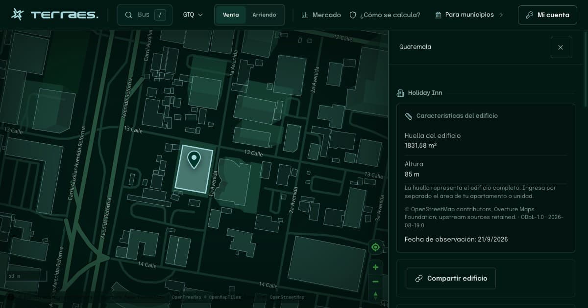
Continue your research
Find a building by address in Guatemala City
Use the municipality and zona to locate an address, select the right building outline and understand the limits of the match.
Read guide →02 · GuatemalaLand, building footprint and home area in Guatemala
Identify what each area measures before comparing a plot, an entire building and an advertised home.
Read guide →Sources and review
By Terraes editorial team · Published · Updated
- Registro de Información Catastral de Guatemala — Servicios catastrales · accessed 2026-09-22
- Overture Maps Foundation — Buildings · accessed 2026-09-22
Mapped footprints do not establish legal ownership or apartment floor area. Advertisements describe asking prices; area references are neither recorded sale prices nor official appraisals.