
Montevideo / Research guide
Find a building and look up a padrón in Montevideo
Use an address to research a building and a municipal cadastral reference without assuming the records are already linked.
In Montevideo, locating a building and looking up a padrón, a cadastral reference, are related but separate tasks. A Terraes building page is not confirmation of a cadastral match. Start with the address, then check the object and identity returned by each source.
Identify the physical structure
Open the Uruguay map, search the address with Montevideo and inspect the suggestion. Zoom in to compare the block, street and expected entrance. Select an outline you can identify rather than assuming the address marker is itself the building record.
The Palacio Salvo building page, checked on September 22, 2026, showed a 1,809.73 m² footprint. It cited Overture release 2026-08-19.0 and retained OpenStreetMap attribution. No matched parcel or individual unit area was available in that query.
The recognisable name does not fill the missing cadastral reference or identify an apartment within the structure. Even a prominent building requires the distinction between its physical outline and the records of land or units associated with it.
Use the municipal source for the cadastral lookup
Montevideo's official address-to-padrón instructions direct users through the municipal geographic system to MonteviMap. Start from the municipal SIG page to follow its current map link. Choose address search, complete the street and door number using the suggestions, and inspect the returned padrón information.
Check the location before copying the identifier, then keep the source link and access date. Several entrances or an incomplete street address can create ambiguity; resolve it rather than choosing the first result simply because it is nearby.
Preserve the distinction between the records
You can record that the municipal search returned information for an address and that Terraes separately identifies a structure. A relationship between them needs evidence that they concern the relevant location and object. Visual proximity alone should not become an automatic database match in your notes.
A padrón lookup also does not by itself establish ownership or the interior condition of a particular apartment. This workflow concerns geographic research rather than the legal verification of a transaction.
When saving screenshots, retain the source, date and selection scope. Cropping out the legend can make a building outline appear to be a parcel boundary. The missing parcel match in Terraes remains a limitation of that record even if another source supplies additional information.
Continue with parcel, footprint and unit areas, official geographic sources or the Uruguay hub. The methodology explains shared evidence concepts without making the Colombian estimator applicable to Montevideo.
Watch the walkthrough
Silent video with captions. Press play to load the recording.
Watch page and full transcript →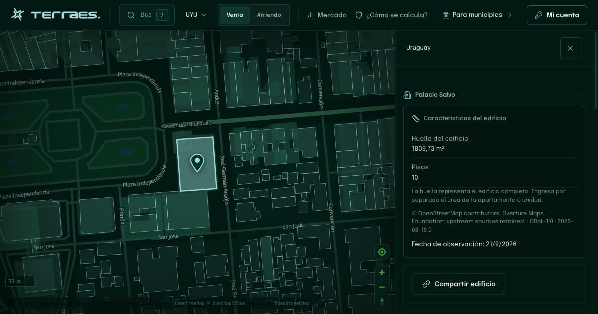
Continue your research
Official geographic sources for buildings and padrones in Uruguay
Choose between Montevideo municipal mapping and national cadastral datasets, checking each resource before joining its information.
Read guide →02 · UruguayPadrón, building footprint and apartment area in Montevideo
Separate a cadastral reference, the outline of a structure and an individual apartment before combining maps and listings.
Read guide →Sources and review
By Terraes editorial team · Published · Updated
- Overture Maps Foundation — Buildings · accessed 2026-09-22
- Intendencia de Montevideo — Sistema de Información Geográfica · accessed 2026-09-22
- Intendencia de Montevideo — Número de padrón a partir de una dirección · accessed 2026-09-22
Mapped footprints do not establish legal ownership or apartment floor area. Advertisements describe asking prices; area references are neither recorded sale prices nor official appraisals.